Oosterhout Formation

Code
NUOO
Status
Formal (Doppert et al. 1975). Amended (Ebbing & De Lang 2003).
Lithological description

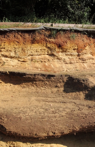
Light grey to greyish green very fine to medium sand, locally clayey, glauconitic, with shells. At the top, dark grey to greyish brown clay, silty or sandy. Shell banks (crags). Locally, yellow to reddish brown medium sand, fossiliferous, partly cemented by iron(hydr)oxides.

Depositional setting

Shallow-marine (shelf and shoreface; clay with tempestites), estuarine, deltaic, beach and nearshore (sand and shell banks; Hodgson 1989).

Definition of lower boundary

Sharp contact with more glauconitic, finer and less shelly shallow-marine sand (Breda Formation) where the base is clayey, gradual transition where the base is sandy.

Definition of upper boundary

Locally exposed at the surface (yellow to reddish brown cemented sand). Elsewhere, gradual transition into (where top is sandy) or sharp contact with (where top is clayey) slightly coarser and less glauconitic shallow-marine sand (Maassluis Formation), sharp contact with coarser fluvial and coastal sand and gravel (Kiezeloolite, Waalre and Peize Formations), or gradual transition into aeolian or local river sand (Stramproy Formation).

Thickness indication
Up to 150 m.
Geographical distribution
Landward transition into and interfingering with coastal-plain and fluvial deposits (Kiezeloolite Formation).
Regional correlation
North Sea: Brielle Ground Formation (defined and mapped in conjunction with the British Geological Survey; Long et al. 1988; Rijsdijk et al. 2005: UK: informal Trimley Sands, Corraline Crag and Red Crag Formations (Mathers & Zalasiewicz 1988; Gibbard et al. 1998); GER: Nütterden and Weeze Schichten; BEL: Lillo, Poederlee, Kattendijke and Kasterlee Formations (Vernes et al. 2018).
Age
late Miocene to Pliocene.
Holostratotype
Well:
Depth (thickness) AH:
106.60 - 262.00 m (155.4 m) below land surface
Parastratotype
Well:
Depth (thickness) AH:
111-183 m (72 m) below land surface
Hypostratotype
Well:
Depth (thickness) AH:
112.00 - 176.50 m (64.50 m) below land surface
Hypostratotype
Well:
Depth (thickness) AH:
217 - 337 m (120 m) below land surface
Origin of name
Named after the city of Oosterhout, in the southern Netherlands.
Previous name(s)
Kattendijk (non-glauconitic part), Luchtbal and Kallo Sands, part of the Merksem Formation, Lievelde Deposits, Scheemda Formation (cf. Van den Berg & Gaemers 1993).
Reviewed by (date)
Wim Dubelaar (2018), Sytze van Heteren (2019).
References
Doppert, J.W.Chr., Ruegg, G.H.J., Van Staalduinen, C.J., Zagwijn, W.H., Zandstra, J.G. 1975. Formaties van het Kwartair en Boven-Tertiair in Nederland. In: Zagwijn, W.H., Van Staalduinen, C.J. (eds.): Toelichting bij geologische overzichtskaarten van Nederland. Rijks Geologische Dienst, Haarlem, 11-56.
Ebbing, J.H.J., De Lang, F.D. 2003. Beschrijving lithostratigrafische eenheid. Nederlands Instituut voor Toegepaste Geowetenschappen TNO. Utrecht.
Gibbard, P.L., Zalasiewicz, J.A., Mathers, S.J. 1998. Stratigraphy of the marine Plio-Pleistocene crag deposits of East Anglia. Mededelingen Nederlands Instituut voor Toegepaste Geowetenschappen TNO, 60, 239-262.
Hodgson, G.E. 1989. Microfacies of the Late Cenozoic southern North Sea. PhD Thesis, University of East Anglia, 431 p.
Long, D., Laban, C., Streif, H., Cameron, T.D.J., Schüttenhelm, R.T.E. 1988. The sedimentary record of climatic variation in the southern North Sea. Philosophical Transactions of the Royal Society London B, 318 (1191), 523-537.
Mathers, S.J., Zalasiewicz, J.A. 1988. The Red Crag and Norwich Crag formations of southern East Anglia. Proceedings of the Geologists' Association, 99, 261-278.
Rijsdijk, K.F., Passchier, S., Weerts, H.J.T., Laban, C., Van Leeuwen, R.J.W., Ebbing, J.H.J. 2005. Revised Upper Cenozoic stratigraphy of the Dutch sector of the North Sea Basin: towards an integrated lithostratigraphic, seismostratigraphic and allostratigraphic approach. Netherlands Journal of Geosciences 84, 129-146. https://doi.org/10.1017/S0016774600023015
Van den Berg, M.W., Gaemers, P. 1993. Tertiair. In: Van den Berg, M.W., Den Otter, C. (eds.): Toelichtingen bij de Geologische kaart van Nederland 1:50.000. Blad Almelo Oost/Denekamp (28O/29). Rijks Geologische Dienst, Haarlem.
Vernes, R.W., Deckers, J., Bakker, M.A.J., Bogemans, F., De Ceukelaire, M., Doornenbal, J.C., den Dulk, M., Dusar, M., Van Haren, T.F.M., Heyvaert, V.M.A., Kiden, P., Kruisselbrink, A.F., Lanckacker, T., Menkovic, A., Meyvis, B., Munsterman, D.K., Reindersma, R., ten Veen, J.H., van de Ven, T.J.M., Walstra, J., Witmans, N. 2018. Geologisch en hydrogeologisch 3D model van het Cenozoïcum van de Belgisch-Nederlandse grensstreek van Midden-Brabant / De Kempen (H3O – De Kempen). Studie uitgevoerd door VITO, TNO-Geologische Dienst Nederland en de Belgische Geologische Dienst in opdracht van Vlaams Planbureau voor Omgeving, Vlaamse Milieumaatschappij, TNO, Geologische Dienst Nederland, Nederlandse Provincie Noord-Brabant, Brabant Water, Programmabureau KRW/DHZ Maasregio.
Cite as
TNO-GDN ([YEAR]). Oosterhout Formation. In: Stratigraphic Nomenclature of the Netherlands, TNO – Geological Survey of the Netherlands. Accessed on [DATE] from https://www.dinoloket.nl/en/stratigraphic-nomenclature/oosterhout-formation.