Ruurlo Formation

Code
DCCR
Status
Formal (Van Adrichem Boogaert & Kouwe 1995).
Lithological description

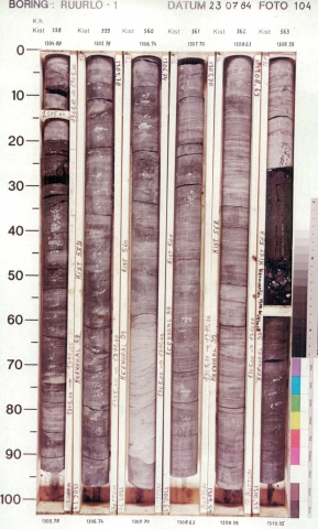
Succession of dark-grey or black, silty mudstones containing a variable number of coal seams (up to 2 m thick), and grey or buff, very fine- to fine-grained, fairly- to poorly-sorted, argillaceous or silty sandstone beds (up to 5 m thick).
The wire-line log patterns of the formation tend to be serrate (ratty), with gentle bell and funnel shapes, reflecting the stacking of fining- and coarsening-upward cycles and the continuous alternation of thin-bedded lithologies.
The formation is characterised by stacking of more or less symmetrical fining- and coarsening-upward sequences with average thickness of 50 m. Gradual upward shift from coarsening-upward- to fining-upward-dominated cycles can be observed, in four discrete stages.
The Ruurlo Formation can be discriminated from the Klaverbank Formation and the formations of the Dinkel Subgroup by the lack of thick, massive sandstone intercalations.

Depositional setting

Poorly-drained delta and fluvial-plain system, building out repeatedly into, and gradually filling up a lake basin, with fluctuation lake levels. Marine incursions (mainly brackish) are scarce.

Definition of lower boundary

Conformably placed on the Baarlo Formation. At the transition the pattern of thick, stacked coarsening-upward sequences of the latter is succeeded by thinner fining- and coarsening-upward sequences.
The boundary is placed at the base of the sandstone truncating the uppermost thick coarsening-upward sequence. An overall shift is frequently observed in the wire-line logs, reflecting the more silty character of the Ruurlo Formation. An increase in coal-seam content can commonly be observed above this level. The Klaverbank Formation is a lateral equivalent in the northwestern offshore.

Definition of upper boundary

Marked by the abrupt transition into the coal-dominated claystones of the Maurits Formation.
Thickness indication
Up to 872 m.
Geographical distribution
Regional correlation
UK: Westoe Coal Formation; GER: Essen & Bochum Formations; BEL: Charleroi Formation.
Age
late Bashkirian.
Holostratotype
Well:
Depth (thickness) AH:
814 - 1503 m (689 m)
Parastratotype
Well:
Depth (thickness) AH:
3036 - 3524 m (488 m)
Parastratotype
Well:
Depth (thickness) AH:
1960 - 2540 m (580 m)
Parastratotype
Well:
Depth (thickness) AH:
3199 - 3777 m (578 m)
Parastratotype
Well:
Depth (thickness) AH:
3175 - 3536 m (361 m)
Parastratotype
Well:
Depth (thickness) AH:
1091.5 - 1690 m (598.5 m)
Parastratotype
Well:
Depth (thickness) AH:
1915 - 2675 m (760 m)
Parastratotype
Well:
Depth (thickness) AH:
3117 - 3722 m (605 m)
Origin of name
Named after the village of Ruurlo in the province of Gelderland, where the type well is situated.
Previous name(s)
For areas outside the eastern Netherlands and southern Limburg, NAM & RGD (1980) proposed no subdivision of the upper part of the Limburg Group. The name Coal Measures (DCCM) was used in those areas.
Reviewed by (date)
Tom van Hoof (2017).
References
NAM & RGD 1980. Stratigraphic nomenclature of The Netherlands. Verhandelingen van het Koninklijk Nederlands Geologisch Mijnbouwkundig Genootschap 32, 77 p.
Van Adrichem Boogaert, H.A. & Kouwe, W.F.P. 1995. Stratigraphic nomenclature of The Netherlands, revision and update by RGD and NOGEPA, Section C, Silesian. Mededelingen Rijks Geologische Dienst, 50, 1-40.
Cite as
TNO-GDN ([YEAR]). Ruurlo Formation. In: Stratigraphic Nomenclature of the Netherlands, TNO – Geological Survey of the Netherlands. Accessed on [DATE] from https://www.dinoloket.nl/en/stratigraphic-nomenclature/ruurlo-formation.