Botney Member

Code
DCCKB
Status
Formal (Van Adrichem Boogaert & Kouwe 1995). For the Netherlands, use of this unit as a member is not encouraged.
Lithological description

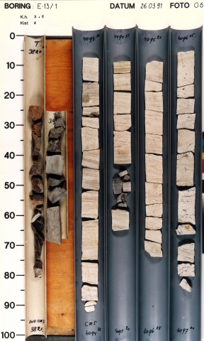
Alternation of stacked, sheet-like, amalgamated channel fill sandstone bodies, mudstone intervals and coal seams. Sandstone intervals show thicknesses of 3 to 25 m, with an average around 10 m. On logs they commonly display a bell shape. The sand is cream to pink, fine- to very coarse-grained, locally conglomeratic and/or carbonaceous, rounded to subangular, well- to poorly-sorted and well-cemented. Sandy mudstone intercalations can reach 25 m in thickness, and locally account for 50% or more of the bulk volume. Coal seams can constitute up to 5% of the member.

Depositional setting

Poorly to moderately-drained fluvial-plain with short-term marine incursions. Sandstones: braided fluvial channel systems, entering the basin from the north. Individual channels frequently amalgamated into sheets. Some fluvial systems were structurally confined, resulting in stacked sandbodies. This system was intermittently replaced by poorly-drained flood-plain, swamp or lacustrine systems.

Definition of lower boundary

Placed at the base of the lowermost thick sandstone bed of the sandstone-dominated interval. This bed truncates the uppermost clear coarsening-upward cycle.

Definition of upper boundary

The transition into the overlying Maurits Formation is marked by the abrupt transition of thick-bedded (pebbly) sandstones into a thick succession of dark-coloured mudstones with abundant coal seams.
Thickness indication
Up to 500 m.
Geographical distribution
Regional correlation
UK: Caister Formation; GER: not present; BEL: not present.
Age
The base of the formation is diachronous, depending on the timing of the first peat (coal) growth, varying between Namurian B/C (UK Quadrant 41) and Early Westphalian A (UK quadrant 48). The top of the formation practically coincides with the Early-Late Westphalian B boundary (‘Domina’ marine band). This coincides with the Bashkirian.
Holostratotype
Well:
Depth (thickness) AH:
3886 - 4297 m (411 m)
Parastratotype
Well:
Depth (thickness) AH:
3950 - 4277 m (327 m)
Parastratotype
Well:
Depth (thickness) AH:
3738 - 4273 m (353 m)
Origin of name
Named after the Botney Ground, a fishing ground in the central North Sea.
Previous name(s)
None.
Reviewed by (date)
Tom van Hoof (2017).
References
Van Adrichem Boogaert, H.A. & Kouwe, W.F.P. 1995. Stratigraphic nomenclature of The Netherlands, revision and update by RGD and NOGEPA, Section C, Silesian. Mededelingen Rijks Geologische Dienst, 50, 1-40.
Cite as
TNO-GDN ([YEAR]). Botney Member. In: Stratigraphic Nomenclature of the Netherlands, TNO – Geological Survey of the Netherlands. Accessed on [DATE] from https://www.dinoloket.nl/en/stratigraphic-nomenclature/botney-member.