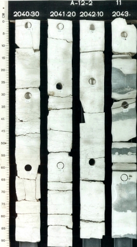
Succession of white, yellowish-white or light-grey, fine grained limestones, in places argillaceous. Layers of chert nodules can be common over large intervals. Along the basin edge coarse, bioclastic limestones and tongues of glauconitic sandstone occur. The formation comprises mainly hard, dense limestones (as result of compaction and cementation), but in its upper reaches it tends to be softer and more chalky in texture.
Deposited under relatively stable, low-energy conditions in carbonate-shelf and upper bathyal environments. The rocks consist essentially of pelagic, biogenic remains, which settled from suspension. A variety of subfacies has been recognised, reflecting variation in sedimentation rate and water depth. In many localities Campanian-Maastrichtian fossil associations indicate considerably shallower water conditions than Turonian-Santonian associations (e.g, lower plankton/benthos ratio).
The boundary with the Texel Formation is usually well marked by a wire-line log kick, indicating the presence of the Plenus Marl Member. Where this member is absent the Texel Formation is recognised by the slightly more serrate, higher gamma-ray readings. In those parts of the Central Graben and Broad Fourteens Basin, where inversion occurred during the Subhercynian phase (Santonian-Campanian), a thin cover of Ommelanden Formation may rest unconformably on older deposits (Schieland Group, Scruff Group, Altena Group, or Upper Germanic Trias Group), which represents onlap of the post-inversion development of the formation. In the far southwest of the country, on the London-Brabant Massif, the Ommelanden Formation can rest unconformably on deposits of the Limburg Group, Carboniferous Limestone Group or Banjaard Group. On the crest of the Mid-North Sea High / Elbow Spit High the unit can onlap onto the Farne Group or Old Red Group.
Across most of its range the formation is overlain by Cenozoic sands or clays of the Lower or Middle North Sea Groups. In this case the upper boundary can be recognised easily by the lower gamma-ray response and higher acoustic velocity of the chalks on wire-line logs, coinciding with a marked change in lithology and colour. Where the Ommelanden Formation is overlain by the Ekofisk Formation the boundary may be somewhat difficult to pinpoint. However, the gamma-ray curve of the Ommelanden Formation tends to show a slightly lower response and smoother pattern. The formation has a somewhat higher porosity in its uppermost reaches compared to the basal beds of the Ekofisk Formation, as can be observed on the appropriate wireline logs. Very rarely a high peak is seen on the gamma-ray log, representing a Cretaceous/Cenozoic boundary clay layer.
