Code
ROCLH
Status
Formal (NAM & RGD 1980).
Lithological description
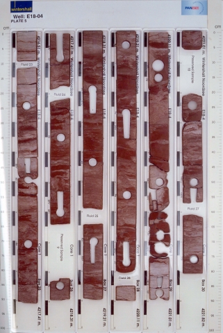
Red-brown clay- and siltstone interval with a few sand-/siltstone stringers.
Depositional setting
Mudflat to playa lake.
Definition of lower boundary
Unconformably on the Limburg Group. Generally, the Limburg Group stands out on porosity logs by a higher degree of compaction.
Definition of upper boundary
Conformably overlain by the Lower Slochteren Member. The boundary has been placed at the base of the first prominent sandstone or conglomerate bed (see Mijnlieff et al 2011, Appendix B, Figure B2e).
Thickness indication
Up to 50 m.
Geographical distribution
Regional correlation
UK: ?; GER: ?; BEL: -.
Age
Capitanian - Wuchiapingian.
Holostratotype
Depth (thickness) AH:
3314 - 3349 m (35 m)
Hypostratotype
Well:
Depth (thickness) AH:
3940 - 3948 m (8 m)
Origin of name
Named after the village of Hollum on the Wadden island of Ameland.
Previous name(s)
None.
Reviewed by (date)
Harmen Mijnlieff (2017).
References
NAM & RGD 1980. Stratigraphic nomenclature of The Netherlands. Verhandelingen van het Koninklijk Nederlands Geologisch Mijnbouwkundig Genootschap 32, 77 p.
Van Adrichem Boogaert, H.A. & Kouwe, W.F.P. 1994. Stratigraphic nomenclature of The Netherlands; revision and update by RGD and NOGEPA, Section D, Permian. Mededelingen Rijks Geologische Dienst, 50, 1-42.
Cite as
TNO-GDN ([YEAR]). Hollum Member. In: Stratigraphic Nomenclature of the Netherlands, TNO – Geological Survey of the Netherlands. Accessed on [DATE] from http://www.dinoloket.nl/en/stratigraphic-nomenclature/hollum-member.
