Klaverbank Formation

Code
DCCK
Status
Formal (Van Adrichem Boogaert & Kouwe 1995).
Lithological description

Alternation of white, light-grey or pink, massive, carbonaceous sandstones, dark- (brownish) grey to black silt- and mudstones and frequent coal seams. In the basal interval the formation displays a characteristic pattern of stacked coarsening-upward sequences. In the younger part, this pattern changes into combined fining- and coarsening-upward sequences. Sandstones are stacked channel fills, forming sheets of 3 to 25 m thick. These are concentrated in the tops and bases of the depositional cycles. Sandstones largely consist of argillaceous, subangular, moderately- to well-sorted, very fine- to coarse-grained sand. At some intervals, the sands are conglomeratic and devoid of argillaceous matrix. Mudstone intervals are silty or very fine-grained sandy and carbonaceous. Cored intervals show small-scale coarsening-upward cycles, capped by sand/ siltstone beds, coal seams or seat earths. Coal seams are rarely up to 3 m thick, and constitute 1 to 5% of the formation.

Depositional setting

Alternation between poorly-drained delta plain and lacustrine basin, with occasional marine incursions (Guion 1988; Cowan 1989; Collinson 1993).

Definition of lower boundary

The base of the sandstone bed underlying the deepest coal seam, or the lowermost coal seam if no sandstone is developed. The deposits of the underlying Millstone Grit Formation are similar, but lack the coal seams.

Definition of upper boundary

Overlain conformably by the Maurits Formation. At this boundary the succession changes abruptly to a thick mudstone interval, generally with abundant intercalated coal seams.
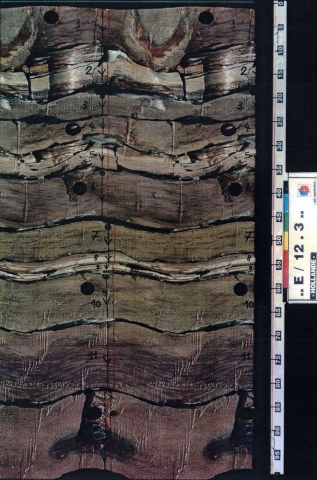
Thickness indication
Up to 156 m.
Geographical distribution
Regional correlation
UK: Westoe Formation, lower part: Caister Formation, upper part: Cleaver Formation; GER: various formations; BEL: Chatelet Formation, Chareleroi Formation, Flénu Formation.
Age
late Bashkirian.
Holostratotype
Well:
Depth (thickness) AH:
3886 - 4565 m (679 m)
Comments:
Thusfar, no released well in the Netherlands has penetrated this unit completely. Only a few wells from the adjoining UK offshore have yielded a complete succession.
Parastratotype
Well:
Depth (thickness) AH:
3950 - 4277 m (327 m)
Parastratotype
Well:
Depth (thickness) AH:
3738 - 4273 m (535 m)
Origin of name
Named after the Klaverbank (= Cleaver Bank) High, where this formation is found.
Previous name(s)
None.
Reviewed by (date)
Tom van Hoof (2017).
References
Collinson, J.D., Jones, C.M., Blackbourn, G.A., Besly, B.M., Archard, G.M. and McMahon, A.H. 1993. Carboniferous depositional systems of the Southern North Sea - ln: Parker, J.R.. (ed.): Petroleum Geology of Northwest Europe, Proc. 4th Conf., 677-687 - Geol. Soc. London.
Cowan, G. 1989. Diagenesis of Upper Carboniferous sandstones: southern North Sea Basin - ln: Whately, M.K.G. & Pickering, K.T., (eds.): Deltas: sites and traps for fossil fuels - Geol. Soc. London, Spec. Publ., 41, 57-73.
Guion, P.D. & Fielding, C.R. 1988. Westphalian A and B sedimentation in the Pennine Basin. ln: Besly, B.M. & Kelling, G. (eds.): Sedimentation in a synorogenic basin complex - the Upper Carboniferous of Northwest Europe, 153-177 - Blackie, Glasgow.
Van Adrichem Boogaert, H.A. & Kouwe, W.F.P. 1995. Stratigraphic nomenclature of The Netherlands, revision and update by RGD and NOGEPA, Section C, Silesian. Mededelingen Rijks Geologische Dienst, 50, 1-40.
Cite as
TNO-GDN ([YEAR]). Klaverbank Formation. In: Stratigraphic Nomenclature of the Netherlands, TNO – Geological Survey of the Netherlands. Accessed on [DATE] from https://www.dinoloket.nl/en/stratigraphic-nomenclature/klaverbank-formation.