The new version of 'subsurface data' of dinoloket.nl is now live. Last year we paid a lot of attention to both user-friendliness and what goes on under the hood.
User-friendly
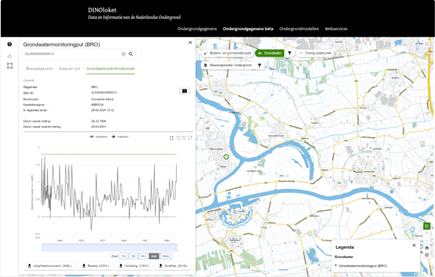
We have incorporated many of the user requirements we have collected over the past time into this new version. Also we have taken a critical look at the existing functionality. Most functionality has been transferred to the new version, but with a more modern look. The map remains interactive during usage. You can easily switch between objects and add them to your order. The visualizations have also been improved. This includes visualizations for water levels, bore hole profiles, etc. We have also made it possible to submit 'feedback' (‘terugmeldingen’) on the map for data from the Dutch Key Register of the Subsurface. If you see an issue in the data, you can report it this way.
Under the hood
The source code has also been almost completely updated. A modernisation that makes for great improvements. It makes it easier to make changes, interaction is smoother and the map viewer of DINOloket is also more manageable. Software has also been prepared for new Kubernetes environment. This means a big step in scalability: if demand increases, capacity grows with it.
More to come
In the near future we will continue to work on new features and adding new subsurface data. Such as BRO data of the Mining Act and BRO data of Site Quality. In addition, we continue to work on performance improvements and new features. For example, our GIS software stack is being renewed, which will offer more possibilities. By the way, one thing we have already realised is that well and pump tests can now also be viewed on the map.
Take a look around our new DINOloket mapviewer for subsurface data and leave your feedback. In the left bar of the map viewer is a black ?-button with the help function. There you will find a practical explanation of how to use the updated map application. Temporarily, it is also still possible to use the old version of the map viewer for subsurface data.