On 12 October 2023, Geological Survey of the Netherlands (part of TNO) has expanded GeoTOP to include the new model area 'Almere' which includes the south-western Flevopolder and parts of the surrounding waters. The new version of the BRO GeoTOP model (v1.6) is available on DINOloket from today.
GeoTOP is a 3D model of the shallow subsurface of the Netherlands. In it, the subsurface is subdivided into millions of voxels (blocks) measuring 100 x 100 x 0.5 m. Each voxel contains several attributes that provide information on stratigraphy (layer structure) and lithological class (soil type, e.g. sand, clay or peat). The model estimates these attributes based on hundreds of thousands of borehole descriptions from DINO and BRO. A large part of the Netherlands (about 70%) is now covered by the model, with the model area of Almere added since 5 October 2023.
Added value model area Almere
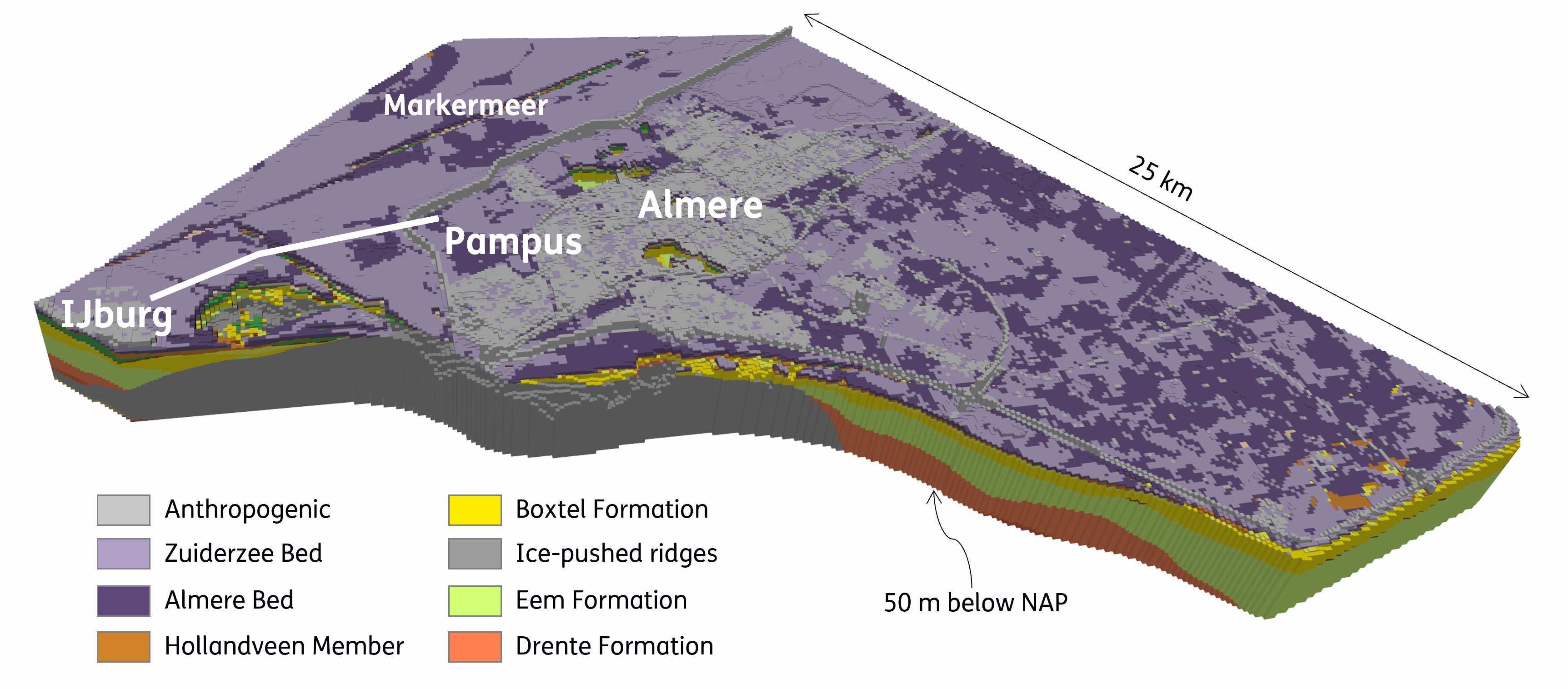
The GeoTOP model area Almere comprises the subsurface of the south-western Flevopolder and parts of the surrounding waters: Markermeer, IJmeer and the peripheral lakes Gooimeer, Eemmeer, Nijkerkernauw and Nuldernauw. In the polder, the model area includes the city of Almere and areas where new residential areas are planned, including Almere Pampus and Eemvallei Stad. In addition, the model area includes the subsurface of the route of a possible new road and rail connection across the IJmeer between Almere Pampus and IJburg. Developing these new buildings and infrastructure requires subsurface information to take into account subsidence, water management, and to look for suitable locations for geothermie. The new GeoTOP model area meets this need.
Geology of the new model area
The subsurface of Almere contains an ice-pushed ridge flanked on the west by the glacial basin of Amsterdam and on the east by the basin of Amersfoort. The basins are filled with sand and clay layers (Eem Formation) that are important for drinking water supply. The Holocene sequence consists of thin layers of clay and peat formed in successively Lake Flevo, Lake Almere, the Zuiderzee and Lake IJssel. Of the anthropogenic deposits, the fill sand in the city and the large dykes around the polder are clearly visible in the GeoTOP model. A special aspect of the dykes is that they are dug in to just above the Base Peat Layer; a clever piece of engineering work that is unique in the Lake IJssel region.
Boreholes and cone penetration tests
In the model area, about 8,000 borehole descriptions were present in DINO at the start of modelling project. To this, about 5,500 auger holes from the archives of the Rijksdienst voor de IJsselmeerpolders (RIJP; the National Office for the polders in Lake IJssel) were added. In addition, the municipality of Almere supplied 3,800 shallow boreholes from its own archive. This made a total of about 17,300 DINO borehole descriptions available for GeoTOP Almere. This dataset was further supplemented by over 400 borehole data from the BRO. In the shallow range (the range of auger holes), the data density is thus very high compared to other model areas. In addition to the borehole descriptions, 12,000 cone penetration test data (CPT’s) from the BRO and 13,000 interpreted cone penetration test data from the municipality of Almere were used to better determine the depth location of the top of the Pleistocene surface.
Historical information
Many of the data of the auger holes we used in creating the model were made in the first period after the reclamation (1968). However, because the thickness of the upper clayey and peaty layers has decreased due to shrinkage and compaction, the surface level has subsided by 1 to 1.5 m. The borehole descriptions therefore provide historical information about the structure of the shallow subsurface that is no longer valid today. In order to still be able to use the borehole descriptions, we have corrected both surface level height and layer thickness for the subsidence that has occurred since the reclamation.
Adjustment of model areas Noord-Holland and Rivierengebied
The new model area Almere has overlap in the west and south in GeoTOP with the existing model areas Noord-Holland and Rivierengebied. The parts that overlap with the new model area Almere have been removed from these existing model areas. In this way, the most up-to-date information is shown in GeoTOP. Noord-Holland and Rivierengebied have therefore become a bit smaller in the new version of GeoTOP. The other model areas already present in the previous version (GeoTOP v1.5) have not been changed.
Towards a nationwide GeoTOP
Geological Survey of the Netherlands (part of TNO) started modelling the still missing parts of GeoTOP in 2023, namely the shallow subsurface of the Lake IJssel region, Drenthe and the Eastern Netherlands (collectively referred to as 'Eastern Netherlands'). We expect to deliver this large model area in 2026. Zuid-Limburg will follow in the following years as the final piece with which GeoTOP will reach national coverage.
Want to know more?
View or download the BRO model GeoTOP v1.6 on the DINOloket map. More information about GeoTOP can also be read on the Explanation page. The model is accompanied by a conceptual model, a realisation report and a quality assessment document. These documents are included with the download of the model and can also be found on the want to know more page of DINOloket.
BRO models, such as GeoTOP, and BRO data are also available on BROloket.